Woodward Avenue, Saginaw Trail

“Indian Trails” Mason, Philip P., 1959. Michigan highways from Indian trails to expressways: manual to accompany filmstrip. Prepared for the Michigan Historical Commission through the Munson Michigan History Fund. Detroit. Print copy University of Michigan.

“Michigan Expressways.” Mason, Philip P., 1959. Michigan highways from Indian trails to expressways: manual to accompany filmstrip. Prepared for the Michigan Historical Commission through the Munson Michigan History Fund. Detroit. Print copy University of Michigan.
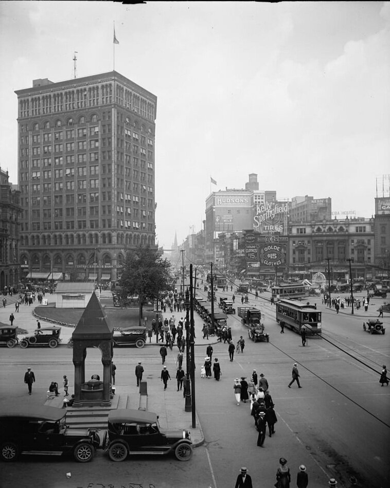
Looking at a map, any map of Detroit, we see Woodward Avenue splits the city in half. Unlike other industrial cities developed around tenements and high-rise apartments, Detroit’s urban geography consists largely of single-family homes built quickly to accommodate the rapid influx of workers.[i] The cheap frame-and-brick homes remain the majority of the housing stock, where they haven’t been demolished or burned down. The exception is Woodward, a wide cut through the city marked by noteworthy architecture and ongoing development. Running a total of 21.5 miles from downtown Detroit to Pontiac, Michigan, Woodward Avenue is the Motor City’s most storied street, a site for dispossession and racialized violence as well as celebration and resistance. During the Great Rebellion of 1967, police shot and killed Carl Cooper, Aubrey Pollard, and Fred Temple at the Algiers Hotel. After leaving a bar in Highland Park in 1982, out-of-work white autoworkers murdered Chrysler machinist Vincent Chin on Woodward, blaming him, a Chinese-American, for Japan’s dominance in the auto industry.[ii] Since 1995, the Woodward Dream Cruise, “presented by Ford,” has occupied the street with nostalgia for the drive-in restaurant era, now numbering tens of thousands of classic cars and at least a million participants and spectators.[iii] Gone along with the Algiers Hotel are the original Detroit Athletic Club, J.L. Hudson’s and Co. (one of the first and largest department stores in the world), and the international ferry dock to Windsor, Ontario, operational from 1921-1939.[iv] Today, the architecture of modernism anchors the built environment of Woodward Avenue, including Ford Highland Park Plant, Temple Beth El, Detroit Institute of Arts, Detroit Public Library Main Branch, Detroit Historical Society, and the Fox Theater — all built, between 1900 and 1928. The campus of Wayne State University, partially abutting Woodward, takes its name after “Mad” Anthony Wayne, the Revolutionary War veteran credited with ending Native resistance in the “Northwest Territories” of Ohio, Michigan, Illinois, and Indiana.[v]
On Woodward, Albert Kahn designed Temple Beth El, and Ford Highland Park. As a member of the Arts Commission, Kahn hired Paul Cret as principal architect for the Detroit Institute of Arts. He also designed the new Detroit Athletic Club on Madison Avenue and the Fischer Building just a few blocks to the west of Woodward. As the designer of countless automobile factories, including Ford’s River Rouge plant — commemorated in Diego Rivera’s Detroit Industry murals at the DIA — Kahn was the architect of Ford and therefore the architect of modernity. His buildings constituted, in Craig Wilkins words, “grand and noble gestures” to “the white cites of Athens and Rome, from which the symbols of our national architecture have been appropriated; the white marble on the white Capital; the white temple White House.”[vi] Along with Ford’s Sociological Department, Kahn’s focus on efficiency also demonstrated architecture’s “long history of being used to perpetuate spatial dichotomy and marginalization,” viewing “the urban condition as an inevitable illustration of the pathologies of its residents, becoming a place to mitigate, not to cultivate.”[vii] Thus, while Kahn’s design’s supposedly incorporated the “high idealism in humanitarian concerns,” improvements in lighting, ventilation,
temperature control, and sanitation at the Rouge plant acted as alibis for brutal working conditions, the logic being healthier, happier workers could be pushed harder.[viii] Artists and architects like Moholy-Nagy of the Bauhaus and the fascist Le Corbusier admired the Rouge plant not for its architectural achievement, but for its “overwhelming monumental power.”[ix]
Over the last half decade, Woodward Avenue has again become the primary site of redevelopment in Detroit. Recent additions include Whole Foods (the only chain supermarket in Detroit), Little Caesar’s Arena (Detroit Red Wings), Comerica Park (Detroit Tigers), and Shinola Hotel. The city, along with a handful of private investors, built a three-mile trolley along Woodward called the QLine. Thanks to the emergency manager, Billionaire financier Dan Gilbert now owns countless properties along the thoroughfare, including “Hudson Site.” The former location of Hudson’s department store will soon be a mixed-used monstrosity or, in the words of the architect, “city within a city.”[x]
Also known as Michigan Highway One, Woodward followed the path of many Michigan Highways over a previously established Indigenous trade route. As we can see in the comparison of “Indian Trails” and “Michigan Highways,” the Saginaw Trail became Woodward Avenue and Michigan Highway One. The U.S. settler nation-state built itself on the infrastructure of existing nations and networks at the same time it claimed the right to own through the labor and discourse of “improvement.” Improvement ensured conquest. Mason writes,
The lack of an adequate transportation system delayed the settlement of [Michigan]. In the first three decades of the nineteenth century thousands of settlers poured across the Allegheny Mountains to take up homes in the recently acquired Northwest Territory. Michigan, however, was bypassed by the settlers, who, instead, chose to settle in Ohio, Indiana and Illinois. Although the Indian menace and the widespread unfavorable accounts about Michigan's poor soil and climate were major reasons for this situation, equally important was the lack of adequate roads.[xi]
The street has been a site of development and contestation since Judge Augustus Woodward arrived in 1805 — the same year Michigan became a U.S. territory — to design and rebuild the city after the great fire. Woodward’s proposal for Detroit followed the L'Enfant Plan for Washington D.C., a spoke-and-wheel design connecting a “system of interlocking hexagons with the center of each hexagon … to be used for public purposes — churches, schools, and markets” (fig. 3).[xii] The treelined streets would radiate around each center and Grand Circus Park in the heart of downtown would be a hundred-foot circle connecting Madison, Park, Washington, Miami (Broadway), Woodward, and Adams Avenues. Woodward envisioned Detroit as the “Paris of the West” with “wide, shady boulevards and conveniently located shops and plazas.”[xiii] Considering the plan too ambitious, Governor William Hull and other civic leaders cut the Grand Circus Park into a half circle with Woodward Avenue emanating from the center of the flat side to the north of the city. They set the rest of the city follows a grid pattern, but many of the street names remained the same. Judge Woodward denied naming the street after himself, saying instead the name described its direction “wood-ward” from the river. A number of reporters in historical record accept this description, but his response was clearly a flippant retort to Hull.
The same year Woodward arrived in Detroit, officials began to make roads across the state, if not for travel, then at least to improve communications. However, the U.S. government didn’t take territorial officials seriously until the War of 1812 demonstrated both the necessity of a broader communication system and the strategic positioning of Michigan on the border with British-held Canadian territories. Over the next century, material limitations, funding shortages, and inconsistent government support meant rocky, marshy, stumpy, and gravely roads until the latter part of the century.[xiv] At that time, new types of roads and surfaces — including tar, oil, asphalt and macadam — expanded Michigan highways. In 1884, Detroit historian Silas Farmer wrote of Woodward Avenue,
This avenue is par excellence the avenue of the city, with one terminus at the river's edge, and the other reaching in a straight line for an indefinite distance into the country. Of an unusual width, and with an ever-increasing number of the most elegant stores and residences along its route, it is probably excelled by no avenue on the continent. It stands as a type of progressive American ideas and is eminently modern and stylish.[xv]
In 1909, Woodward Avenue between Six Mile and Seven Mile roads became the first paved highway in the U.S. More than thirty-five million vehicles traveled the mile-long stretch before it was replaced in 1922.[xvi]
Throughout the 1920s and 1940s, city planners focused expansion and redevelopment efforts for the city on Woodward Avenue, including several efforts to widen the road requiring the city to assert eminent domain over shop-owners and homeowners. In 1924, Albert Kahn sat on the widening committee. In 1944, an effort to control signage on Woodward generated so much backlash that, in a lawsuit to prevent expansion, business owners demanded the city prove it actually owned the avenue. Responding to the hearing, an uncredited March 9, 1944 news item on the front page The Detroit Free Press argued if the city’s ownership couldn’t be proven, Woodward Avenue should revert to Indigenous people. Over a photograph looking up Woodward Avenue and its skyline, including Hudson’s tower, a headline in a cursive font, “Anybody See Chief Pontiac?”[xvii] A text box in the lower half of the page begins with two questions in large bold letters: “Giving it Back to the Indians? And “Who Owns Woodward Ave.?” The plaintiffs’ counsel argued, “There is nothing to show that Woodward ever was dedicated by any record to the City of Detroit.”[xviii] Attorneys asked the judge to determine whether Woodward belonged to the City or the federal government, but the reporter concluded their findings “might be interpreted as giving Woodward back to the Indians.”[xix]
The following day, columnist Malcolm W. Bingay responded to the question “Who Owns Woodward Ave?” by suggesting, tongue-in-cheek, he’d like to see land go back to Native people. He wrote, “What we need in this town is bigger and better Indians,” then he explained why Detroit in fact owned Woodward.[xx] In a flippant, ambling account of Judge Woodward’s work in Detroit, Bingay writes, “He took over Detroit as his own personal property” and intimates the judge handed over the city to an ungrateful population before departing for a courtesy judgeship in Florida. However, he ends by saying the final answer to the question “who owns Woodward” can only be found in the judge’s book. Since “A System of Universal Science” doesn’t include any mentions of Woodward Avenue or Detroit, Bingay is merely naturalizing the white possession of Woodward Avenue, a feeling of attachment to place based on “ownership and achievement,” Aileen Moreton-Robinson writes, for “the people who made this country what it is today.”[xxi]
__________
[i] Sugrue, Origins, 21.
[ii] Scott Kurashige, The Fifty-Year Rebellion: How the U.S. Political Crisis Began in Detroit. (Oakland: University of California Press, 2017.), Kurashige, The Fifty-Year Rebellion, 39
[iii] “Woodward Dream Cruise.” Accessed June 3, 2020, http://www.woodwarddreamcruise.com/
[iv] A.J. Bavery, “‘Crashing America’s Back Gate’: Illegal Europeans, Policing, and Welfare in Industrial Detroit, 1921-1939,” Journal of Urban History 44, no. 2, 239.
[v] Tiya Miles, The Dawn of Detroit: A Chronicle of Slavery and Freedom in the City of the Straits. (New York: New Press, 2017), 116.
[vi] Wilkins, The Aesthetics of Equity, 17-18
[vii] Ibid., 69
[viii] Grant Hildebrand, Designing for Industry: The Architecture of Albert Kahn. (Cambridge: MIT Press, 1974), 53, 123.
[ix] Ibid, 120.
[x] Ben Duell Fraser, “Gilbert Breaks Ground for ‘City Within a City;’ Chants Decry ‘Corporate Welfare.’” Deadline Detroit, December 14, 2017, https://www.deadlinedetroit.com/articles/18937/hudson_s_breaks_ground_for_city_within_a_city_chants_decry_corporate_welfare.
[xi] Philip P. Mason, “Michigan highways from Indian trails to expressways: manual to accompany filmstrip.” (Michigan Historical Commission, 1959), 4-5.
[xii] Charles Madden, “How Woodward Got its Name.” Burton Historical Archive, Detroit Public Library. Bin: E&M 977.4D4, 352.71 “Woodward Avenue,” 2
[xiii] Ibid.
[xiv] Mason, “Michigan highways,” 6.
[xv] Silas Farmer, “Guide and Souvenir of Detroit: with map and illustrations” (S. Farmer & Co., University of Michigan Digital Archive, 1891), 4.
[xvi] Mason, Michigan highways 14
[xvii] “Anybody See Chief Pontiac.” Detroit Free Press (1923-1999), Page 1. Mar 09, 1944. Accessed through Detroit Public Library Digital Archives June 3, 2020, https://search.proquest.com/docview/1816692450?accountid=58383.
[xviii] Ibid.
[xix] Ibid.
[xx] Malcolm Bingay, “Who Owns Woodward,” Detroit Free Press (1923-1999), Page 6. March 10, 1944. Accessed through Detroit Public Library Digital Archives June 3, 2020, https://search.proquest.com/docview/1816685550?accountid=58383.
[xxi] Aileen Moreton-Robinson, The White Possessive: Property, Power, and Indigenous Sovereignty. (Minneapolis: University of Minnesota Press, 2015), 4.